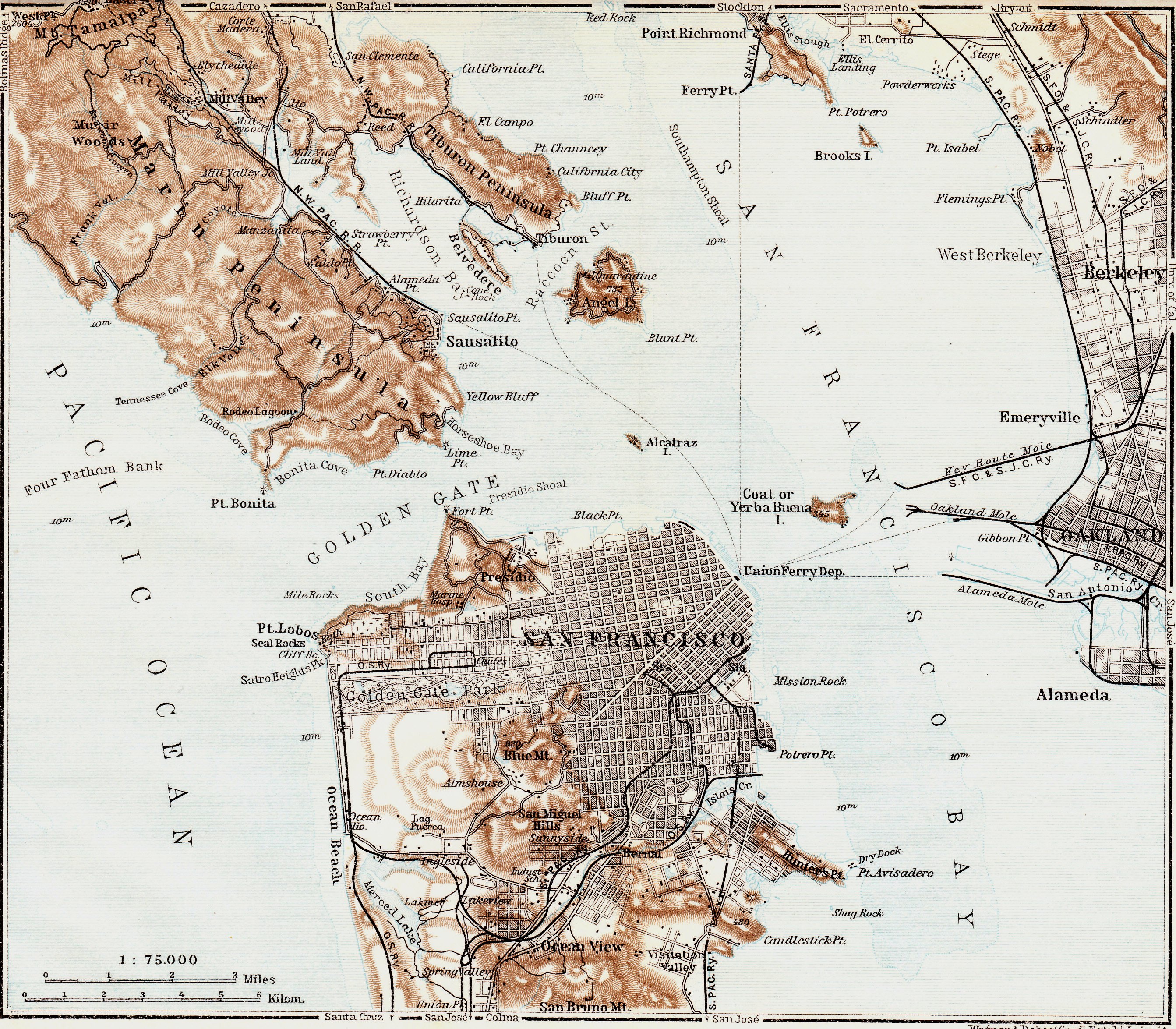
Special thanks to RichmondSFBlog reader Sue for sharing her recent ebay acquisition with us. It’s an antique map of the San Francisco Bay Area from 1909 that was part of a guidebook published by Fritz Baedeker of Leipzig, Germany.
Some interesting tidbits from the map (download full map):
– “The Chutes” is marked in the Richmond District. Located at Fulton and 10th Avenue, it was the first amusement park in the city and the precursor to Playland (photo). You’ll also notice the Marine Hospital is labeled, which is now the Presidio Landmark apartments inside the 15th Avenue gate.
– Most of the Sunset District is still wide open, a.k.a sand dunes.
– Some onhealthy order norvasc areas have names I’ve never heard of. Twin Peaks is labeled as “Blue Mountain”, Tennessee Valley in Marin is referred to as “Elk Valley” (were there elk there at one time?), and Yerba Buena Island is referred to as “Goat Island”.
– You’ll notice “Quarantine” overlaying Angel Island in its upper right corner. That refers to the quarantine station on the north side of the island that was opened in Ayala Cove (then known as Hospital Cove) in 1891. Returning soldiers, and later immigrants, were quarantined there.
Click here to view the full map (2MB)
Notice anything else odd or surprising about the map? Leave a comment to let us know.
Sarah B.
Maps can be fun, but not always accurate. in this case, the maps shows a rail line, marked O.S.Ry. coming from the Sunset, across the end of Golden Gate Park. The drawing completely missed the streets it was intending to show, and the line was only “proposed”, but never built. The Ocean Shore Railway, which was to serve from San Francisco along the coast to Santa Cruz, hoped to build a steam line from the end of the United Railroad line, at 11th and Fulton, north on 11th Avenue to Anza, west on Anza to 17th Ave, and continuing along Cabrillo to the spur along La Playa to connect near Lake Merced and on to Pacifica, Half Moon Bay, etc. The Richmond District residents went ballistic over the idea of a smelly steam train in the neighborhood and the Board of Supes defeated the proposal in 1909. The neighborhood improvement clubs in the Richmond won the day and would continue to wield a lot of clout to bring services to improve the “new” neighborhood. O.S. Ry. could only get about 40 miles south of Half Moon Bay and eventually Southern Pacific outflanked them over the Hwy. 17 route to Santa Cruz, and the automobile interests got Hwy. 1 to serve the area, using some of O.S.Ry.roadbeds.
In Richmond District. the unserved area west of Park Presidio (another map error – it dated from 1903, but is not shown on this map), soon had rail along Fulton to the Beach by 1911. It would have the first Muni line on Geary in 1912. The “hole” in the Richmond wouldn’t have the #31 to serve it until 1932.
It looks like the northern part of the city near the Presidio ended with Filbert St. Did the water really start there or am I counting streets incorrectly? I didn’t realize they filled in so much.
Good point, Marcia. The San Francisco World’s Fair was in 1915, and for that they filled in much of the Marina District:
“And so was the creation of the Exposition, beginning with the placement of 300,000 cubic yards of fill to create land for the site from what had formerly been San Francisco Bay and is now San Francisco’s Marina district. The times were heady, and rapid strides were being made in engineering and manufacturing.” http://www.moah.org/exhibits/archives/1915/
Hard to tell if it’s Filbert on the map but definitely had a different shoreline in that part of the city in 1909! Trippy.
Sarah B.
The roads leading to Belvedere from Tiburon have been built with landfill, but the rest of the lagoon has yet to be filled in.
Also “Blythedale” in Mill Valley is now spelled Blithedale.
I wanted to add that this map tries to do too much without providing enough detail. In the Richmond District, there are not 49 north/south streets shown. The map does not show Lake, Clement, Anza or Cabrillo. So in viewing it, you have to add these features in your mind. By 1909, there would have been a lot more houses in the neighborhood then the scattering of black boxes to indicate structures. Still it has most things right and it’s fun to look at the City grid and topography a century ago.
Appreciate everyone’s very interesting comments about this map — thanks! Rail line is particularly fascinating. The entire map (shown if you click through) is quite small — 6.5 x 5 3/4″ — from Pt Richmond and north of Corte Mader down to Daly City — which explains the lack of detail and the inclusion of only a few features. I noted with interest that there is 1 cross at the Mission Dolores cemetery, no indication of one in the Presidio or at the Marine Hospital (where recent research has indicated that as many as 700 may have been buried).
Yep, Tennessee Valley was called Elk Valley for well over a century. There used to vast herds of elk and even some grizzly bear in what’s now the Marin Headlands — what the Spanish-Mexican residents called Rancho Saucelito.
Nice map, for what it tries to show. Thanks for posting it! Interesting about the Ocean Shore RR line (and commenters’ notes on how it got defeated). The larger story of why they only reached 40 miles down the coast was the city got wiped out by the earthquake and fire not long after the OSRR incorporated. They were one of the RR companies that hauled debris out of downtown to fill in Islais Creek and maybe also the Marina District.
To me it looks as if the Blue Mountain name references Mt. Sutro, elevation 920 feet (dot). Twin Peaks are not named on this map. Blue Mountain was renamed Mt. Sutro in 1911. Dan Schneider of Mt. Sutro Stewards (www.sutrostewards.com) found a letter proposing the renaming while researching the history of trails and land use on Mt. Sutro. We may throw a party to commemorate the anniversary of this change in 2011. A few other maps (notably Chevalier’s exquisite map of 1903/1914, in the online David Rumsey collection) also show Mt. Sutro as Blue Mountain.
You will find some histories of the 1970s and onward that say Mt. Davidson was Blue Mountain, but Dan’s research suggests this was an error (confusion over obscure references) and/or names might not have been 100% pinned down back in the day. Mt. Davidson falls under the general name of San Miguel Hills. Twin Peaks was part of Noe’s (but not Sutro’s) San Miguel Rancho and small maps may have lumped them under the San Miguel Hills name.
Come out and join Sutro Stewards for trail building on 1st Saturday of every month! In October 2010 (if all goes well) we are scheduled to start restoration of the 120+ year-old trail from 17th and Stanyan up to Medical Center Way (connecting with the 0.6 mile Historic Trail we restored in 2007).