Sometimes I am delighted about what lands in my inbox. That was definitely the case when this poem arrived, recently written by Kenneth Werda who grew up in the Richmond District; he is now 82 years old. His sister Joan sent it to me and asked if the blog would be the right place to share it? Absolutely!
I’ve added some SFPL archive images to accompany Kenneth’s references in the poem, all taken around 1947, when he graduated from George Washington High School. Enjoy,
Sarah B.
 AN ODE TO THE NORTHWEST CORNER OF THE CITY
by Kenneth Werda
From “Hilltop High” I can see the Bay
all my realm before me lay
I marvel at the vast array
and know here’s where I want to stay
My stucco house all painted white
will catch the sun and reflect its light
in all the world no other sight
could fill my heart with such delight
Arguello, Geary and Clement
along these streets my boyhood spent
days and years of such content
a Richmond District resident
I think of days now gone before
saddened there will be no more
of dunes and sand and open land
the “Col”, the “Al” so very grand
Sutro’s house and old Playland
all gone by the wrecker’s hand
If heaven’s doors allow me in
I know my face will wear a grin
’cause I’m sure what I will see
is my old Richmond there for me
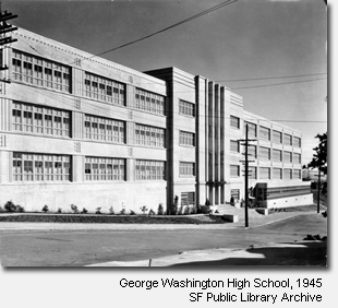
Taken from the roof of George Washington High School, aka “Hilltop High”, June 16, 1945.
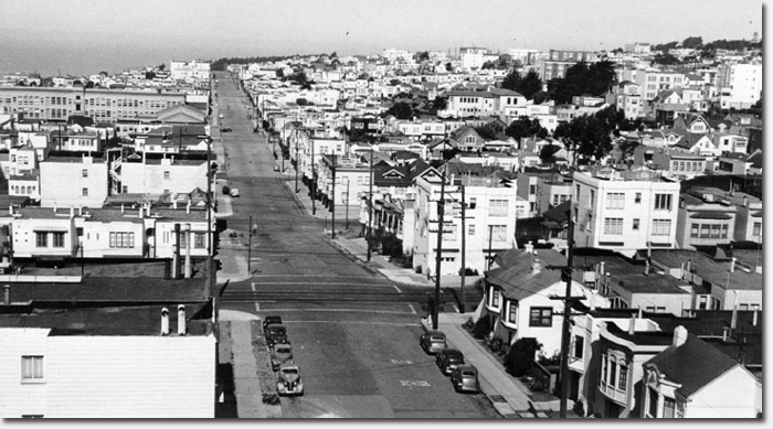
Looking west on Anza to the ocean | Courtesy SFPL
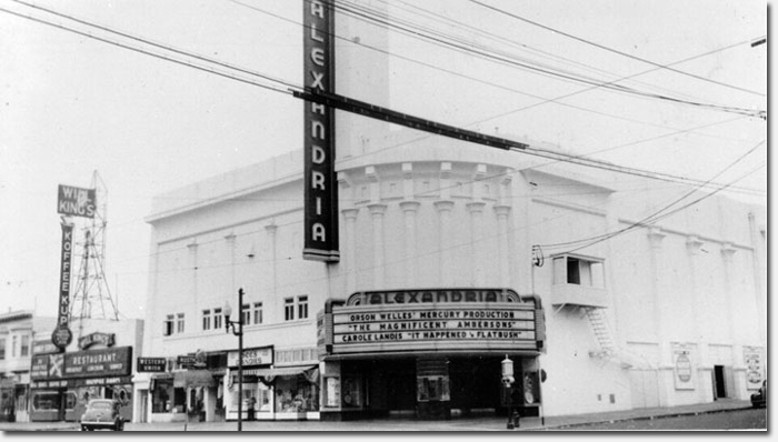
The Alexandria Theater, Sept. 25, 1942 | Courtesy SFPL
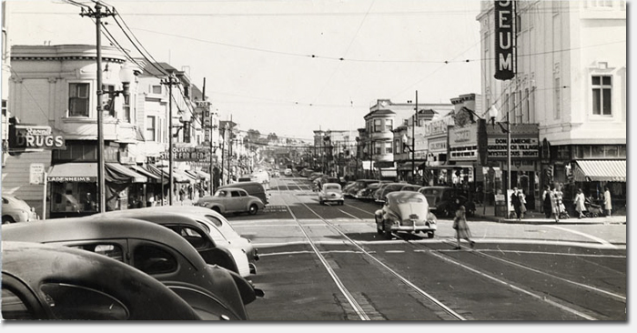
The Coliseum Theater, 1944. Corner of Clement and 9th Avenue (now a Walgreens). | Courtesy SFPL
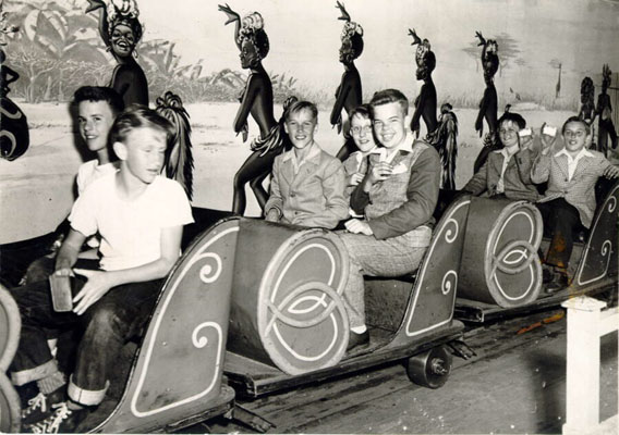
Group of boys on a ride at Playland at the Beach, July 14, 1947 | Courtesy SFPL
One downside to seeing old photos (which I love) is the reality those buildings were there before I was born and will be there after I’m gone.
Great tribute to the Richmond. First line, unfortunately is not geographically accurate, since you get fabulous views of the ocean from Geo. Washington HS – west is ocean, and north is the ocean entrance to Golden Gate. But “bay” makes a better rhyme sequence, so we can excuse the poetic license taken. Excellent job of pairing photos to poem!
love it
John, there are many vantage points from GW High where you can see the bay:
http://www.hsfootballweb.com/sfwashhs%20stadium.jpg
Oh, and I meant to say also, how is the entrance of the Golden Gate not part of the bay? Officially, the bay starts prior (west) to the GG bridge, it’s not just the part between SF and Oakland.
I haven’t been inside GWHS but I bet from the top floors you could probably see the bay bridge. You can clearly see the financial district from the ground where Anza ends on the east side of the school (I walk around the neighborhood a lot.)
Lovely poem!
Loved the poem! Thanks for sharing it.
The maritime maps show the Pacific Ocean, Golden Gate Straight and San Francisco Bay. The straight starts at Lands End and ends at the Golden Gate. From GWHS, you can only see a small sliver of SF Bay on the east side of the Golden Gate. What you do see more of is the GG Straight. I taught 9 years at Washington and enjoyed the view daily. Even from Room 300, in the NE corner of the classroom building, you can only see a small section of the bay near the north anchorage of the bridge. Washington is built on a 260 ft. hill and Robb Hill in the western side of the Presidio is at 374 ft, cutting off your view of the Bay. Add to that Presidio Heights and Russian Hill and you see why there is only the slightest peek of San Francisco Bay from the school. I think the confusion is calling the Golden Gate Straight part of San Francisco Bay – it is only a corridor from the ocean to the bay.
To get technical, there are many bays within the bay, including South Bay which lies West of the GG Bridge. Collectively, they are all often referred to as San Francisco Bay, even though there is an actual bay named San Francisco.
But as you say, this is poetry, not cartography. It’s probably harder to rhyme ‘the straight’, and people still wouldn’t know what you’re talking about. 🙂
I love the look of “the Koffee Kup” — can we please have it back?!
Dear Gary,
You HOPE these buildings will be there. So do I — but if City Hall and the developers have their way, we may not even recognize Geary Blvd. in 10 years.
The city building ordinance allows for buildings taller than the mostly 1-3 story buildings currenlty along Geary. City Hall and the developers in this city see “The Geary Corridor” as a place where they could build…believe me, they want to get rid of the old buildings a build much higher ones — apt. buildings, condos, subsidized housing. If you don’t know about the BRT, I suggest you find out.
Most of us voted for light rail thinking it was a great and “green” idea — but we dind’t understand the insidious motives behind that measure.
swhat the city’s own studies show is that, in reality, BRT will result in our getting downtown some 3 minutes faster…and for that, The Richmond will have Geary torn up (in different sections) for at least 2 years…with all the traffic mess, the parking all blocked off, etc. You may have noticed the increasing number of empty shopfronts — that’s because our local merchants are barely hanging on in this economy and with competition from large “box stores,” etc. Tearing up the street is highly likely to force many of them out of business. And with no businesses paying leases, a lot of those buildings will go up for sale…and VOILA! golden opportunity to developers and the city to change our neighborhood’s character entirely.
I have lived here all my life — and I LOVE our old, low-rise buildings…imagine how Geary would look if both sides were buildings as tall as the new “institute on Aging” residences on Geary. All of Geary could end up looking like the area around the ballpark — oh and of course, we have our Speedway Meadows as a venue for major concerts 6 onths a year, too…and we’ll have soccer fields with 60-ft stadium lights and rubber grass.
My stomach turns at the thought. If yours does, too…please look these issues up online .
To be elected mayor this year requires that the candidate carry the Richmond distrcit. We’re the key, swing vote! (yes!!!)
So write to Eric Mar and contact the candidates for Mayor and make sure they know what you want and that they will NOT get your vote unless they pay attention to what the residents of the Richmond want for GGPark and for Geary Blvd.
I’m not for unmanaged growth, and I feel for the merchants along Geary, but as more people move to the city, they have to go somewhere. There’s no land left so the option is to build up. I’m not advocating skyscrapers along Geary but taller buildings means more residents which means more people that can support those local businesses that are going under. Circle of life.
Personally, if I cared about it more, I’d write Eric Mar and tell him that I’d like *more* festivals at GG park. Those types of events are what make GG park what it is, rather than a giant swath of greenery sitting there with no personality.
I live a couple blocks from the soccer fields and people make it seem like there are no lights in this part of the city and the fields will be some sort of abomination. What with the streetlights all over the place and 24 hour bus lines, I can’t see how some floodlights so kids can play soccer at night will really matter.
That’s the way I remember it. I Walked to Alamo from 21st avenue then on to Presidio until the 6th grade and finally up the hill to GWH. I have great memories from the Richmond District.
Thanks Dave for bringing it all back for a few moments.
We visited San Francisco last week on our way to Carmel for our 50th anniversary. Didn’t have an opportunity to visit the old neighborhood on this trip but maybe in the next year or so.