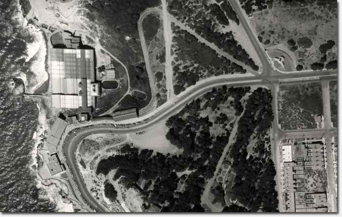
An aerial view in 1938 over Sutro Baths and the Cliff House
Via their twitter, the SF Public Library turned us onto a fascinating map that gives you a bird’s eye – or what we’d now call satellite – view of San Francisco in August, 1938. It’s great fun to zoom in and out, exploring the city.
The map is a composite image of a set of 164 high quality, large format, black and white vertical aerial photographs that partially overlap. The photos were taken by Harrison Ryker in 1938, who according to the map’s biography, “teamed with various pilots beginning aerial photography services out of the Oakland Airport and throughout the West.”
In the Richmond District, you get a nice overhead view of the monstrous Sutro Baths complex (as seen above), as well as blacked out portions of federal land in the northwest corner.
It wasn’t until 1940 that we had a Park Presidio extension onto the Golden Gate Bridge and Doyle Drive, so you’ll see the boulevard wind its way into the Presidio instead.
We also noticed what is now the campus for Katherine Delmar Burke School at the end of California adjacent to Lincoln Park was then a complex of sports courts (one of those tennis courts still exists).
In the neighboring Sunset District, the most interesting part is what’s not there. Blocks and blocks of sand dunes still existed in the heart of the outer Sunset in 1938.
This is a really fun map to explore. If you find other interesting tidbits in the neighborhood, let us know in the comments. Enjoy!
Sarah B.
WOW I just spent a hour looking at that zoom map, looking at things that were there before I was born. Sand dunes still in the Sunset too.
This is neat! Thanks for sharing! 🙂
For those interested in an equally old map (1945), download Google Earth and turn on the Historic Image slider. Lets you go to aerials from 1945, 1975, 1991 and then from 1999 up to today (on an almost quarterly basis).
Couple of things I noticed: Golden Gate Park scrub/sand area before the 9 hole golf course was built, … the small Norwegian? ship just north of Beach Chalet (zoom in),…. and to see that the Beach Chalet soccer fields had 4 soccer fields and 1 football field back in the day (even more than today’s fields).
Also cool to see what was blacked/whited out, specifically the artillery batteries at Baker Beach
Google earth doesn’t even have their timeline images go back that far they only go back to 1946 and the ones on google earth are nowhere near as clear as these ones. Amazing find!
I can see my house and how it was before previous multiple owners changed it in a attempt to “modernize” it, wish I had views of say from the 1910’s and 20’s.
I put together a mash-up of the online photos with the Sutro Stewards trail map to find out where the trails fall on the landscape of 1936, and if any traces of the old 1880s trails are visible.
http://www.peasepress.com/share/UC%20SutroTrails+1938.jpg
Yellow trails are modern; dots are original routes of trails, generally steep ones we’ve rerouted in the last 5 years. Compare to the current trail map at http://sutrostewards.org/page/trail-map
As it turns out, few of the oldest trails appear — they’re hidden by the dense eucalyptus forest in 1936, they were likely already abandoned and overgrown for 40 years. But we do see a few footpaths sneaking into the forest edges, plus 20th century forest roads we’ve crossed or used in our trail network. The eucalpytus forest on the south and west slopes is recently thinned for fire reduction/firewood gathering (as chronicled in Outside Lands article on Sutro Forest). The widely-spaced trees on the south and west slopes cast long shadows.
Also worth a look are the old cemeteries at the east end of the Richmond District; see the Columbarium in context. Look for a big landslide on the west edge of USF (Parker north of Turk)
Hat tip to David Rumsey and SFPL, and of course the Richmond Blog.
@Rob S.: That’s true. These images are significantly higher quality and older. Was simply suggesting additional images for those that are interested. I can spend hours browsing these aerials.
We could start a rumor that the Trader Joe’s parking lot (former cemetery) is haunted…
My first encounter with these photos a couple weeks ago, they were all posted as individual photos (remember these are kitchen table-sized prints!). Now, clicking on your sample photo of Sutro Baths opens up a single image of the whole city, which you can zoom in on to explore the entire city seamlessly. Very cool.
Although as Ken said a lot of the Presidio’s military sites are blocked out, there is plenty of interest as far as habitat — both along Lobos Creek Dunes and over by Inspiration Point/El Polin Spring areas, before the post-war housing was built. There was no Inspiration Point pullout off Arguello Blvd, but there were also very few trees to block the view (the area where the trees were removed was primarily meadow and serpentine grassland). There was not yet a debris dump off Quarry Road/Kahn Playground (target of the huge “restoration” project now in progress). Quarry Road is very informal and ends up somewhere different than it now does.
I also notice there was some older housing just being built along MacArthur Rd. down near El Polin Spring, more in scale with the older 1930s housing over by Lovers Lane, that seems to have been demolished and replaced by today’s Wherry Housing.
You posted earlier this year about 25th Ave. being the primary access to the Golden Gate Bridge (and mention above the lack of McArthur Tunnel in the Presidio). Down in Golden Gate Park, work is just starting on Hwy 1/Park Presidio Bypass. It looks as if they had just dug up all the trees, leaving a pock-marked slope. Not sure if they were just digging out rootballs or salvaging trees for later replanting.