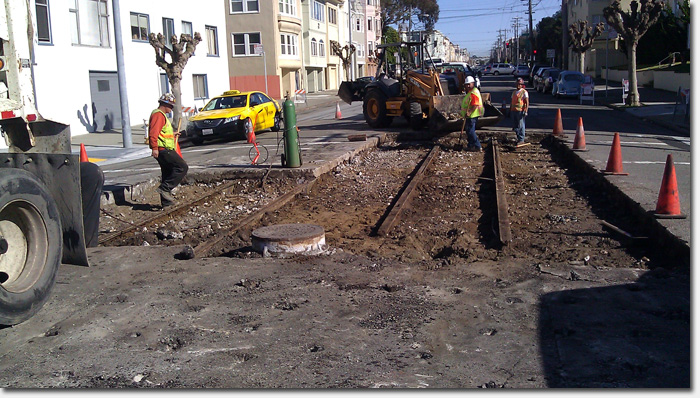
Road crews uncover old streetcar tracks during sewer work.
As we move around in our modern world, we tend to forget how things used to be. But every now and then, during the most meaningless of moments, we are reminded.
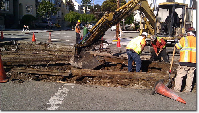
That’s what happened on Monday, when cub reporter David H. came upon a road crew on California between 15th and 16th Avenue. The street had to be opened up for some sewer work and as crews dug in, they stumbled upon a piece of San Francisco’s transit history – old streetcar tracks.
“The wooden ties were a bit rotted but the rails and spikes were as good as new,” David said. He even snagged a couple of the spikes for his collection.
After seeing pics of this accidental archaeological dig, I contacted Richmond District historian John Freeman to get more background on the streetcars that used to run along California Street.
California Street had the first rail line that went completely through the Richmond, as the steam train of the Ferries and Cliff House Railway. It opened September 30, 1888 to take passengers from the end of three cable car lines that terminated at Central Avenue (now Presidio Avenue) at the Laurel Hill Cemetery, to Sutro Baths and the grand chateau Cliff House which opened in 1896.
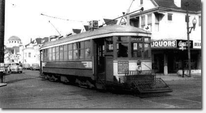
The C streetcar at 2nd Avenue & Clement, 1948. Courtesy outsidelands.org
John says the rails uncovered on California Street could date as far back at 1905. The #1 Sutter and California streetcar may have traveled on them. According to outsidelands.org, the C Geary-California streetcar line began running in 1915 out to Park Presidio / 13th Avenue as the Municipal Railway’s seventh route. The line was then extended to 33rd Avenue and California in 1915.
But with progress comes changes, and on July 3, 1949, all rail service on the California Street trolley tracks ended, to be replaced by buses. The Richmond District did have the B-Geary streetcar line up until December 1956, when it was replaced by the #38 bus line.
John says that simply covering over the streetcar rails was a common practice. Just a few years ago, he saw a similar scene on Balboa when they were doing roadwork.
“You would think the rails had salvage value, but in a post-WWII world, scrap steel was not very valuable and it was cheaper to cover the rails than to remove them for their scrap value,” John told me.
Special thanks to David H. for snapping pics and to John Freeman for providing the background on what was uncovered.
Sarah B.
Looks familiar, I have similar photos of Balboa showing the uncovered tracks from a few years ago.
Great post! Thanks!
It would be nice to bring back the streetcars.
Thanks for the history & photos.
So then, the obvious question is, is it possible to extend Muni out this way, and not have to make massive changes on Geary? Why not bring the larger streetcars out, which would alleviate the 38 congestion on Geary? If the tracks go all the way downtown, this is a no-brainer. No need for Bart or a Muni extension; it already exists.
And of course, imagine the embarassment had we actually built a Bart or Muni extension, only to find out that two locks away the tracks already existed? This is actually pretty major; why not look into this further?
Surface trains running on the street (like the F-line on Market) wouldn’t be that much faster than the buses are now. What would make a bigger difference is dedicated lanes and traffic signal prioritization so that buses/trains don’t have to queue up and wait with all the car-driving chumps. If you do that stuff then it doesn’t make as much difference whether the vehicles run on tires or rails.
I think that picture of the C streetcar is a reverse negative, based on the location of temple emanuel
I think it’s safe to say that the tracks wouldn’t be reused, even if you were putting a streetcar line in the same place. They wouldn’t be up to modern standards.
Carl: Nope, it’s looking down 2nd Ave. The house on the corner is totally unchanged.
And while I wouldn’t object to a streetcar line on California, if you only have one it makes sense to run it down the middle of the Richmond, so Geary is the obvious choice.
The historic photo is correct, because the buildings in the background behind the trolley is the NE corner of 2nd Ave. & Clement, where Eats is today. The C streetcar didn’t compete with the California Cable Car downtown. It ran out Geary along with the B line, but turned north on 2nd Ave. for two blocks to California Street, to continue outbound to the end of the line at 33rd Avenue. The photographer is in the 300 block of 2nd Ave. facing north. That is why you see Temple Emanuel in the distance.
Whoops I see it now. What threw me off is that I expected the tracks to be going east-west on Clement not north-south on 2nd Ave.