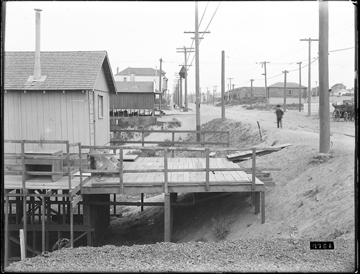
Raised Frame Houses on California Street Between 17th and 18th Avenues | July 20, 1908. Courtesy of SFMTA Archives
The Western Neighborhoods Project sent this pic our way. It shows California Street near 17th Avenue in 1908, just two years after the big quake.
The structure in the foreground of the photo is an Earthquake Refugee Cottage or “earthquake shack” as they’re often called. Some residents re-purposed them into homes after they were used to house quake refugees between 1906 and 1908 at camps throughout the city. This one was probably moved from the Camp 25 (Camp Richmond) refugee camp that spanned Park Presidio (photo below).
Now if we could figure out if this is looking east or west, we’d post a “today” photo to compare it to… [Update: John Freeman confirmed the photo is looking east, so photo from today is posted below]
Sarah B.
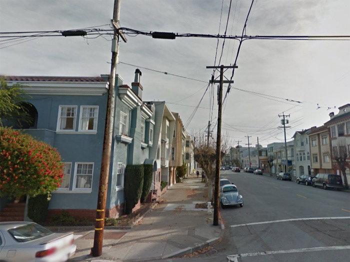
The “today” shot looking east on California at 18th Avenue. Wonder if those are the
same utility poles that were there in the 1908 photo?
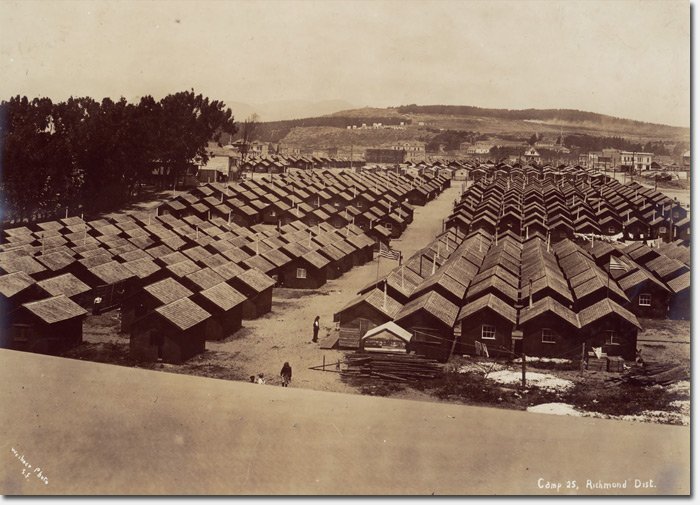
Camp 25 located along what is now Park Presidio Boulevard. Courtesy Bancroft Library.
Is that all sand?
@Maru – Yup!
Sarah B.
The photographer was facing east. This sure has all the characteristics of the earthquake shack I worked on in 2005. The left side of the street appears to drop off, and the house was supported by piers and bracing because this is the original drainage down to Lobos Creek. It is hard to imagine that the original topography of the Richmond District was composed of pretty lumpy and bumpy hills and valleys of sand. There was a major sand hill around Clement St. from about 16th to 20th Avenues that had to be cut down before they could lay streetcar tracks or grade Clement Street (you see a little bit of that hill behind the Alexandria Theatre still today). California St. was easier to grade.
Camp #25 footprint was essentially Park Presidio today, from Lake to Anza, but there was one block used between 14th & 15th Avenues, Clement to Geary, created to move camp residents originally placed north of Lake St. near Mountain Lake, further away so they could minimized human-waste contamination of the lake. You can kind of make out that one-block dog-leg on the left of the picture, near the stand of Eucalyptus.
In The Camp 25 photo:
The two buildings in the distance, just to the right of the stand of trees, each two-story with a small attic window in the eaves, would according to John Freeman’s post be at the NE corner of Clement St and 15th Ave. And indeed they are still there. Likewise the building at the NE corner of Clement & 12th.
Believe the Camp 25 picture is taken facing north.
4thGenRichmond- yes, you are correct. The photo was taken on the hill between Anza and Balboa (A & B Sts. then), looking north toward the Presidio.
This is so interesting! I live about 1/2 block from here, in a house that was built in 1907 with earthquake rubble. It rests slightly below street grade, so I wonder if it was also in the Lobos Creek drainage area, as John Freeman points out? Now I want to research it.
That’s where we live, top level of the blue house. Apparently it was once a single family home but now it’s split into 2 units.