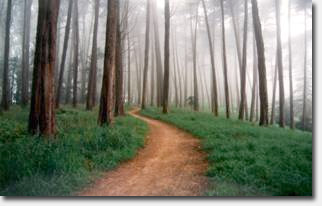
 This Saturday, the Presidio is offering a guided tour of the brand new Park Trail in honor of National Trails Day. The Park Trail begins at the top edge of Mountain Lake Park, then winds down through the Presidio and finishes at Crissy Field.
Once a military zone, the Park Trail winds through majestic old growth, past a historic cemetery, and around the recently opened Presidio Habitats exhibition, a site-based art show celebrating the wild Presidio that showcases temporary habitat sculptures.
The Park Trail is about 2 miles onhealthy ponstel long with moderate terrain. The guided tour leaves from the Presidio Officer’s Club (50 Moraga Avenue) at 1:30pm on Saturday. Registration is required so call 561-5418 or email presidio@presidiotrust.gov
If you can’t make the guided tour, download the Presidio Trails Map to walk the new Park Trail on your own. The Presidio Habitats exhibition is also worth checking out – get all the info on the show and the self-guided tour on their website.
Thanks to Matt Baume for the tip.
Sarah B.
Bah. Less a “Park Trail” and more a “follow these existing streets to get to Chrissy Field.”
Unfortunately the linked map is a little old, so the best part of the Park Trail doesn’t show up yet. Between Mountain Lake and Washington Blvd. the Park Trail simply uses old Park Blvd through the golf course, which has been open a while to hikers (if you don’t mind the risk of errant golf balls). But north of Washington down to Lincoln, the trail is almost all new; just left of the “Area B” label the trail has been routed off of the road and into the woods. Halfway down (northward) there’s a spur trail over to the Cemetery Overlook (also pre-existing, but rebuilt with steps). About a block after crossing Lincoln (at a new 4-way stop) you meet the new Presidio Promenade bike path from the main post to the bridge. In a couple years you will be able to continue safely past all the construction down to Crissy Field.
Just the short leg of new trail on the north slope of the ridgeline you can make a greater variety of loops, whether coming from the Bridge, Arguello Gate, or Mountain Lake.
The link for the exhibition map does show the new Park Trail, on the right edge over by artworks 6 and 7. Lots of switchbacks and turns whereas before you either had to walk the road or the trails went straight and steep. It looks indirect on paper but it walks very nicely.
Thanks for the info– I’ll have to check it out soon.