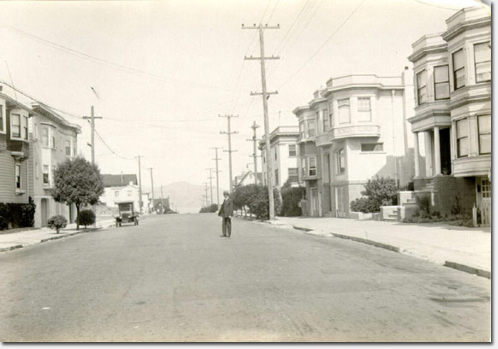
Browsing through the SF Public Library’s great photo archive recently, I came across this shot of a man standing on an unidentified street in the Richmond District. I figured it was a good chance to quiz all the RichmondSFBlog readers to see if anyone could identify the location.
And before you ask, I’m not sure what street it is either. All I can deduce is that it’s looking north – I believe that’s the Marin Headlands in the distance – and is most likely west of Park Presidio. Leave your guess in the comments!
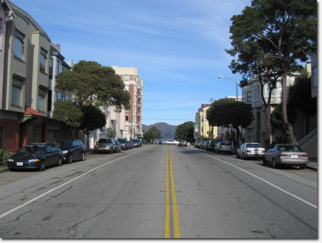
UPDATE: Mystery solved! RichmondSFBlog reader alyxandr correctly identified this as 25th Avenue between California and Lake (looking north).
Thanks to historian John Freeman for providing the photo below, a present day shot that shows the same building on the right side of each photo (now the Kittredge School). John says the original photo was taken in 1925 by Jesse Cook, a Richmond District police officer who worked his way up to Chief, but returned to the streets as an inspector. He used to take pictures all over the city in the 1920s, some because they were the scene of auto accidents and others just for the fun of it.
Sarah B.

Somewhere between 27th to 30th at the crest of Anza, before the hill descends to Geary.
I wonder if that print is flipped…
I don’t think the print is flipped, from the contour of the hill in the background; as is it matches a north-facing view of the headlands. the crest of anza is a definite possibility, but also either 26th or 27th avenue between california and lake (which gives a better match of the background, but still not a good match for the houses or tree patterns…
good challenge!
Yeah, it’s interesting – perhaps it’s the angle and lack of cars that make the street look really wide. And the sidewalks look deeper than normal, perhaps because there are very few trees. I look forward to us solving this one!
Sarah B.
It’s funny, I went through this a few months back with this same picture, though I don’t know where (or if) we published the info
It’s 12th Avenue looking north between Clement and California, the space on the left would become Sutro School.
whoops, I think I might be confusing this one with another one.
Yeah, I don’t think that’s 12th Avenue having just looked on Google Maps. Keep thinking people! 🙂
Sarah B.
Based solely on Google Maps, i’m guessing 25th (which is indeed wide, being 3 lanes there) between California & Lake. Heading out armed with a print of the photo and a picnic, will report back this afternoon. 😉
Based on the placement of the marin headlands, it looks like it is either 25th Ave or 26th Ave. My guess is 26th btw Clement and California, but it is hard to tell. The buildings in the picture are no longer there if that is the right location.
Got it in one: This was taken on 25th, just south of halfway between California and Lake. There are several buildings that match, the clincher being the 2nd visible (actually the 3rd, there’s one recessed) on the right, which is 220/222 25th; after little or no remodeling, it still has the half-brick wainscotting (except i don’t think you call it that on the exterior) and distinctive ground-floor front and side windows. The large empty area to the middle left, at the corner of Lake, is now a horrible ’50s or ’60s-looking beige apartment building.
Based on Redfin, it looks like 25th ave between California and Lake. I think the far right building is the Kittredge School. The buildings buildings on the left appears to have been replaced.
Yep, alyxandr is right. I was examining Google Maps and had noticed the match with 220/222 25th. Also, the building on the left side that is partially blocked by the tree looks to be the current 215/217 25th.
Well done alyxandr! I will post a Google Maps side by side later tonight to compare and contrast.
Sarah B.
“half-brick wainscotting” = watertable 🙂
Definitely 25th ave between California and Lake, the lines on the house next to Rochambeau playground match up exact.
Here’s the link: http://maps.google.com/maps?q=220+25th+ave&ll=37.785165,-122.485102&spn=0.007538,0.011684&sll=37.785251,-122.485093&sspn=0.006295,0.006295&layer=c&cbp=13,6.93,,0,-3.75&cbll=37.785071,-122.485098&gl=us&t=h&z=17&panoid=zg5fgx98r_GAfvh1V61BqQ
How about that six-story building? When they built it (1930, according to the city website, same year as the other six-story building on 16th & Clement), they probably thought there would be hundreds more to follow. Nope.
@Caitlin – thanks!
Thank you, sleuthhounds – from the San Francisco Public Library! The information will be added to the record for the image.
LOL, it would take a brave (or foolish) soul to stand like that on that street today.