Click to enlarge
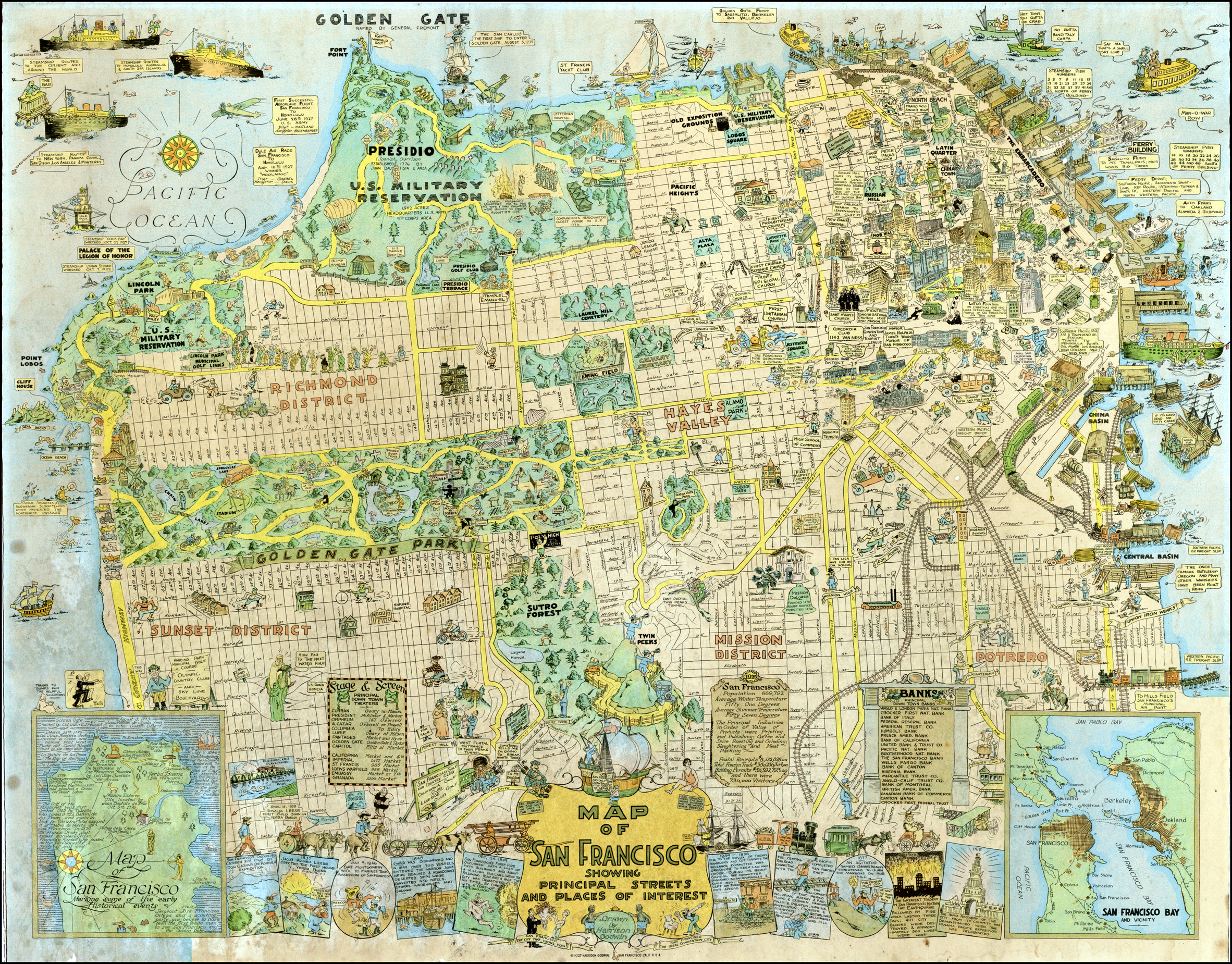
In it, a group of men are lined up to play the Lincoln Golf Course, and the shipwrecks off of Land’s End are marked (steamships Lyman Stewart in 1922 and Coos Bay in 1927). The map also shows the Mile Rock lighthouse in its full splendor, complete with the caretaker’s residence on top of it.
The Lurline Pier, which used to carry water from the Pacific all the way to downtown saltwater pools, is pictured on the north end of Ocean Beach with divers jumping off it. And a tourist is perched atop Sutro Heights Park taking pictures over the Cliff House. A man waves his arm atop a rollercoaster at Playland.
There are a couple of head-scratchers that some history buffs may be able to shed light on. Around Anza and 33rd Avenue two figures are playing baseball which may be a reference to the area around what is now George Washington High School (the high school didn’t open until 1936). And around California and 29th Avenue, a man, perhaps a sailor, is on rollerskates.
And not far from what is now the Landmark Apartments just inside the 15th Avenue Presidio gate is a Blimp Hangar. Say what? There’s also a Victorian house plopped down at 9th Avenue and Balboa; we’re not sure what that is.
UPDATE: Historian John Freeman provided some more explanation on the Presidio hangar: “There was a short-lived experiment by the Coast Artillery to send spotters up in tethered balloons to communicate with the shore batteries about how accurate their projectiles landed in the water during target practice. The westerly winds and bobbing gondolas that made the spotters sea sick caused the project to be abandoned. The balloons were stored in a hanger at the open lot off Lincoln Blvd., east of the 25th Ave. entrance, later converted to the army motor pool.”
John also had some insight into the “rag man with his horse and wagon tooling through the Richmond”: “I can even remember seeing and hearing him calling out “rags, bottles, sacks” as he traveled up and down the streets. I don’t think the junk man was limited to just this neighborhood, but as a kid, that was my world. I don’t know if you would have known when he’s come by your block, but I can see housewives running out to his wagon with their “recycling” and I receiving a few coins for their saved discard. The garbagemen did separate recyclables on their truck to make coffee money, but the “rag, bottles. sack” man actually paid a small amount when he came by. The practice was greatly curtailed during WWII when everyone was doing recycling “for the war effort”, with metal being the highest priority. The Boy Scouts were the primary labor force and were organized to help people bring out their recycling, pile it in front of homes, and toss it on the truck when it came down the block.”
Godwin does a nice job of spotlighting Golden Gate Park, picturing the bison, a pole vaulter at the Polo Fields, a man picking fruit on Stow Lake’s Strawberry Hill, and various figures reclining around the park reading or snoozing.
The map is available as a print up to 50″ in size, and can be cropped to feature your favorite part of the city.
In un-internet fashion, we couldn’t find much online about the artist, Harrison Godwin, other than “Born in New Jersey on March 21, 1899. By 1930 Godwin had settled in Carmel. He died there on Jan. 11, 1984” (askart.com). Godwin also created similar tourist maps for places like Hollywood, CA.
Sarah B.
Notice the cemeteries where USF now is. I heard they were populated with Chinese immigrants who’s graves were moved to Colma to make way for development. I wonder if they really got them all? Kinda creepy!
Anyone else have any insights into the history of that?
Thanks!
Shane J.
Fun map, but not to be totally taken literally. The artist did take liberties by using a bath tub for Sutro Baths, and a diver plunging off the Salt Water pier (gated, so off limits!). The placement of the baseball players near Washington High, which was a quarry at the time, was his way of filling space, or an indicating that the Richmond had a number of playgrounds (as was the roller skater). The Victorian home is another broad reference for the Inner-Richmond, which seems misplaced around 9th Ave. & Balboa St. The fun drawing to me is the balloon and hanger just east of Baker Beach. There was a short-lived experiment by the Coast Artillery to send spotters up in tethered balloons to communicate with the shore batteries about how accurate their projectiles landed in the water during target practice. The westerly winds and bobbing gondolas that made the spotters sea sick caused the project to be abandoned. The balloons were stored in a hanger at the open lot off Lincoln Blvd., east of the 25th Ave. entrance, later converted to the army motor pool.
The popularity of golf in the 1920s is indicated by the long lines leading to Lincoln Park. The former streetcar line around Lands End had washed out for good in February, 1925, so the trolley coming down to the Sutro Station was then the only service to the area.
There is some real history on this whimsical map, but not every drawing is to be taken as proof of historic significance.
Ah, yes the cemetery stories. No Chinese bodies near USF – only members of the Masonic Lodge & their families, but there were 4 cemeteries surrounding Lone Mountain. There were Chinese buried in Jordan Park briefly, but only vague reference with no specifics sites. The major Chinese burial grounds were in today’s Lincoln Park, where three benevolent societies had plots. But City or Golden Gate Cemetery was like a mall of cemeteries, with paupers, fraternal lodges, Chinese benevolent societies, and 2 minor Hebrew congregations owning sections. All the bodies were supposed to have been removed to Colma, but hundreds were uncovered when they dug the vault and did seismic retrofit work for the Legion of Honor. Actually the Chinese bodies were the least likely to have remained in the ground, because the practice at the time was to remove bodies after a certain amount of time, scrape off the flesh, clean the bones and return them to family plots back in China.
I was mentally paging you, Mr. Freeman 🙂 so thanks for chiming in. What a great story about the hangar – I will add it to the post.
Sarah B.
Fun map. Some historical inaccuracies notwithstanding, wish the mapmaker had included the Fort Point Lighthouse, which was built in 1853, the first of three, I believe. It was finally deactivated in 1933 after the Golden Gate Bridge was built (the bridge blocked the beam of the powerful 4th order lens from throwing its light out to sea).
Shane, there have been articles, pictures and maps regarding the removal of all cemeteries from within SF City Limits in the Western Neighborhoods Project (last item on Links list to the right).
I have a copy of this, reprinted in the 70’s or 80’s. I recall a few years back another fellow selling his own reprint. I was at the Antiques Roadshow taping in Santa Clara a couple months back and saw one set up for filming, hopefully it’s an actual 1927 version.
here’s a short video we did about the cemeteries and reuse of the headstones around the City.
https://www.youtube.com/watch?v=SaMe85iPDIM
What a fun map !
A friend just sent this map to me. I too, was immediately curious about the blimp hangar. The NPS did a wonderfully detailed write-up about the coast artilery balloon program in their historic resource report on the only remaining hangar from the program, which still stands at Fort Baker in the Marin Headlands and (is/was?) used by the Presidio Riding Club as an indoor arena.
It doesn’t line up PERFECTLY with the cartoon, but my guess is that the drawing is supposed to be the blimp hangar at Fort Winifield Scott, which was the same design as the one in the Marin Headlands and built at the same time (7/27/20-6/26/21). The report also cites a third hangar of this sort at Fort Worden in Puget Sound and one of a slightly different design at Ft. Funston on the shores of Lake Merced.
The report even has a picture of the Presidio hangar (on page 10) taken in 1939, so it seems to have stuck around long after the short-lived program was scrapped in 1921. Perhaps it was finally torn down in conjunction with wartime mobilization.
Here’s the NPS Report: http://www.nps.gov/history/history/online_books/goga/balloon_hsr.pdf
@Devin – Very interesting report – love the photo of the balloon in front of city hall! Thanks for sharing
Sarah B.
I recind my comment about the location not lining up right. I guess I hadn’t considered that Fort Winfield Scott could include all the coastal artilery land in the Presidio that far south from the area I usually consider to be Fort Winfield Scott propper, whcih is farther north in the crux of Lioncoln, Doyle Drive/101, and Highway 1.
<>
So sad to compare photos of the lighthouse in its glory before it was automated and the unhappy trimmed-down remodel of today.
http://www.lighthousefriends.com/light.asp?ID=77